Spatial and other neighborhood conditions and obesity
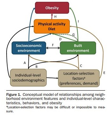
Image from "Obesogenic Environments in Youth: Concepts and Methods from a Longitudinal National Sample." Janne Boone-Heinonen, PhD, MPH, Penny Gordon-Larsen, PhD. American Journal of Preventive Medicine, May 2012. 42:5
The May issue of the American Journal of Preventive Medicine focuses on the use of geographic information systems (GIS) data analysis to study neighborhood characteristics and the impact of these characteristics on health, as laid out in the lead article, "Thinking About Place, Spatial Behavior, and Spatial Processes in Childhood Obesity" and "Obesogenic Environments in Youth: Concepts and Methods from a Longitudinal National Sample."
All of the articles are available "for free" online.
ABC News also did a story, "Obesity Linked to Neighborhood Features: Do You Live in a Fat Neighborhood?," on the issue, summarizing findings from some of the articles. From the article:
In one study [Objective Assessment of Obesogenic Environments in Youth: Geographic Information System Methods and Spatial Findings from the Neighborhood Impact on Kids Study], researchers used geographic information to determine which neighborhoods in King County, Wash. and San Diego County, Calif. rated highest in terms of physical activity and nutrition for children ages 6 through 11. A neighborhood received a high rating if there were ample opportunities to walk to places, such as stores and libraries as well as highly-rated parks.
These neighborhoods also had numerous grocery stores or supermarkets where produce and healthy foods were available.
Neighborhoods that rated poorly had few markets available or had a large number of fast food restaurants and also did not offer many chances to walk or play in high-quality parks. There were also neighborhoods rated in between good and poor.
"The biggest difference we found in rates of obesity were in the places where the environment was good for both nutrition and physical activity, the rates were less than 8 percent, but if the nutrition and physical activity were not good, the rates went up to 16 percent," said Brian Saelens, a co-author and professor of pediatrics at Seattle Children's Research Institute.
Saelens added that researchers controlled for other variables that could contribute to obesity, such as income, family status and parental body mass index (BMI).
In an accompanying paper, Saelens and his colleagues used GIS data to define "obesogenic" environments as those that offer little in the way of physical activity and good nutrition. The authors say GIS measures should be used to assess the relationship between physical activity, nutrition and obesity.
So, this sets up a framework to consider a more expansive view of how to do land use, transportation, parks, and public health planning and what to do when you're doing it.
For example, in the (hopefully) soon to be approved Western Baltimore County Pedestrian and Bicycle Access Plan, for which I was the project manager and chief author, there are many more recommendations concerning "programming" and "communications" as it relates to developing "active transportation" as routinized behaviors.
In the field of bike and pedestrian planning, I argue that the next logical direction for improvement in is the tighter integration of infrastructure recommendations with the development and delivery of programming, as well as integrating multiple spatial scales in plans, taking them down from an entire city or county to the sector/community/neighborhood.
In the field of bike and pedestrian planning, I argue that the next logical direction for improvement in is the tighter integration of infrastructure recommendations with the development and delivery of programming, as well as integrating multiple spatial scales in plans, taking them down from an entire city or county to the sector/community/neighborhood.
You're starting to see this in such plans as the Nashville Regional Bicycle and Pedestrian Study and the Treasure Island Community Transportation Plan in San Francisco, which was not done by a land use or transportation planning agency, but by the Department of Public Health in conjunction with the local bicycle advocacy group.
Labels: food-agriculture-markets, GIS, health and wellness planning, parks planning, public health, transportation planning, urban design/placemaking
posted by Richard Layman @ 6:25 AM&Permanent Link
![]()
![]()


1 Comments:
Enjoyed reading through this, very good stuff, thank you.
Post a Comment
<< Home